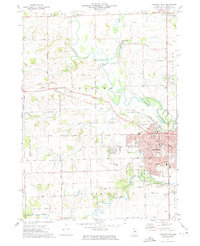
1971 Map of Freeport West
USGS Topo · Published 1974About this map
The western edges of Freeport and the surrounding township of Harlem define this early 1970s landscape, where the urban grid meets the meandering bends of the Pecatonica River. While the city displays established residential streets and civic anchors like Highland Community College and Krape Park, the outlying territory remains deeply agricultural. This rural expanse is punctuated by small settlements and historic points of interest, including the community of Scioto Mills to the north and Preston Bottoms along the river. Transportation patterns are shaped by the Illinois Central Gulf railroad and a network of gravel-extraction sites, shown as multiple Quarry labels. Genealogists will find a wealth of local history in the numerous rural burying grounds such as Hart Cem, Harlem Center Cem, and the Van Brocklin Cem, which anchor the surrounding farmsteads.
Find a feature on this map
60 named features on this map. Tap any name to fly to it.
Don’t see what you’re looking for? This feature index may not catch every label — zoom into the map to look around manually.
Map Details
Editions of this 1971 Freeport West Map
2 editions found
Other maps of this area

1937 · Lena
USGS Topo · 1:48,000

1939 · Freeport
USGS Topo · 1:48,000

1942 · Mt Carroll
USGS Topo · 1:62,500

1942 · Lena
USGS Topo · 1:62,500

1942 · Forreston
USGS Topo · 1:62,500

1943 · Lena
USGS Topo · 1:62,500

1944 · Mt Carroll
USGS Topo · 1:62,500

1944 · Freeport
USGS Topo · 1:62,500

1945 · Forreston
USGS Topo · 1:62,500

1954 · Rockford
USGS Topo · 1:250,000