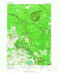
1957 Map of Freesoil
USGS Topo · Published 1965About this map
The Manistee National Forest dominates this landscape, where the Little Manistee River and Big Sable River carve through a glaciated terrain of hills and numerous kettle lakes. Settlement is concentrated around the villages of Freesoil and Fountain, both situated along the Chesapeake and Ohio railroad corridor. The map reveals a transition in rural education, documenting several shuttered facilities such as Claybank Sch and Elm Flats Sch, suggesting a period of school consolidation in Mason and Manistee counties. Historical boundaries are prominently marked, including the Old Indian Boundary that cuts diagonally across the northern townships. High points like the Udell Hills are punctuated by the Udell Lookout Tower, while family-named locales like Tomaszewski and Star Corners reflect the area's agricultural and ethnic heritage.
Find a feature on this map
79 named features on this map. Tap any name to fly to it.
Don’t see what you’re looking for? This feature index may not catch every label — zoom into the map to look around manually.
Map Details
Editions of this 1957 Freesoil Map
3 editions found

Other maps of this area

1931 · Custer NW
USGS Topo · 1:31,680

1931 · Baldwin NW
USGS Topo · 1:31,680

1931 · Custer NE
USGS Topo · 1:31,680

1931 · Manistee SE
USGS Topo · 1:31,680

1931 · Freesoil SW
USGS Topo · 1:31,680

1932 · Freesoil SE
USGS Topo · 1:31,680

1932 · Ludington NE
USGS Topo · 1:31,680

1933 · Peacock SW
USGS Topo · 1:31,680

1933 · Peacock NW
USGS Topo · 1:31,680

1954 · Traverse City
USGS Topo · 1:250,000