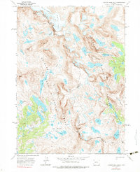
1968 Map of Fremont Peak South
USGS Topo · Published 1983About this map
Fremont Peak and Jackson Peak anchor this high-elevation survey of the Wind River Range, where the Continental Divide forms a jagged boundary between the Shoshone National Forest and the Bridger National Forest. The landscape is defined by its glacial history, with active ice masses like Bull Lake Glacier, Knife Point Glacier, and Harrower Glacier feeding complex drainage systems. To the east, the waters of Bull Lake Creek descend through the Brown Cliffs, while the western slopes contain the extensive Cook Lakes network and the headwaters of Pole Creek. The map documents a strictly non-motorized infrastructure, highlighting the Continental Divide (Pack) Trail and Highline Trail as primary routes through the Bridger Wilderness. This 1960s study captures the region before contemporary climatic shifts significantly altered the margins of these high-altitude glaciers and perennial snowfields.
Find a feature on this map
45 named features on this map. Tap any name to fly to it.
Don’t see what you’re looking for? This feature index may not catch every label — zoom into the map to look around manually.
Map Details
Editions of this 1968 Fremont Peak South Map
4 editions found
Other maps of this area

1909 · Fremont Peak
USGS Topo · 1:125,000

1938 · Mt Bonneville
USGS Topo · 1:62,500

1941 · Mt Bonneville
USGS Topo · 1:62,500

1942 · Mt Bonneville
USGS Topo · 1:62,500

1952 · Bob Lakes
USGS Topo · 1:24,000

1952 · Alpine Lake
USGS Topo · 1:24,000

1955 · Thermopolis
USGS Topo · 1:250,000

1955 · Lander
USGS Topo · 1:250,000

1958 · Lander
USGS Topo · 1:250,000

1958 · Thermopolis
USGS Topo · 1:250,000