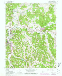
1965 Map of French Lick
USGS Topo · Published 1981About this map
French Lick and West Baden Springs anchor this mid-century portrait of southern Indiana’s mineral springs region. The landscape is defined by the winding course of the Lost River and its subterranean tributaries, which carve through numerous named valleys such as Stillhouse Hollow, Toliver Hollow, and Pipher Hollow. The map documents a transition in infrastructure, showing the Southern and Louisville and Nashville railroads alongside modern utility expansions like Abydel and various Pipelines.
Find a feature on this map
42 named features on this map. Tap any name to fly to it.
Don’t see what you’re looking for? This feature index may not catch every label — zoom into the map to look around manually.
Map Details
Editions of this 1965 French Lick Map
4 editions found
Other maps of this area

1948 · Huron
USGS Topo · 1:24,000

1949 · Georgia
USGS Topo · 1:24,000

1950 · Mitchell
USGS Topo · 1:24,000

1950 · Huron
USGS Topo · 1:24,000

1950 · Valeene
USGS Topo · 1:24,000

1951 · Hillham
USGS Topo · 1:24,000

1951 · French Lick
USGS Topo · 1:24,000

1951 · Georgia
USGS Topo · 1:24,000

1956 · Greenbrier
USGS Topo · 1:24,000

1956 · Vincennes
USGS Topo · 1:250,000