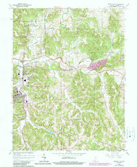
1965 Map of French Lick
USGS Topo · Published 1990About this map
The famed resort communities of French Lick and West Baden Springs anchor this mid-century survey of Orange County, showing the region before significant modern development altered the valley floor. The map traces the winding course of the Lost River as it disappears and reappears through the karst landscape, a feature complimented by numerous named hollows such as Stillhouse Hollow and Pipher Hollow. Local history and genealogy are well-represented by rural landmarks including Ames Chapel and Moores Ridge Ch, alongside family burial grounds like Miller Cem and Springer Cem. A significant historical line, the Indian Treaty Boundary, cuts across the southeastern corner, while the Hoosier National Forest defines the wooded upland terrain. The map also documents the transition from agrarian roots to small-town infrastructure, noting a Quarry, a Substation, and the small settlement of Abydel.
Find a feature on this map
38 named features on this map. Tap any name to fly to it.
Don’t see what you’re looking for? This feature index may not catch every label — zoom into the map to look around manually.
Map Details
Editions of this 1965 French Lick Map
4 editions found
Other maps of this area

1948 · Huron
USGS Topo · 1:24,000

1949 · Georgia
USGS Topo · 1:24,000

1950 · Mitchell
USGS Topo · 1:24,000

1950 · Huron
USGS Topo · 1:24,000

1950 · Valeene
USGS Topo · 1:24,000

1951 · Hillham
USGS Topo · 1:24,000

1951 · French Lick
USGS Topo · 1:24,000

1951 · Georgia
USGS Topo · 1:24,000

1956 · Greenbrier
USGS Topo · 1:24,000

1956 · Vincennes
USGS Topo · 1:250,000