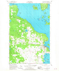
1954 Map of Friday Harbor
USGS Topo · Published 1968About this map
Friday Harbor serves as the focal point of this maritime landscape, captured during the mid-1950s as a vital hub for the San Juan Islands. The town’s harbor is protected by Dinner Island and Little Island, with the Oceanographic Laboratories established on the northern point. The interior of San Juan Island reveals a mix of agricultural and wooded terrain, notably through the Beaverton Valley and the elevations of Cady Mountain and Little Mtn.
Find a feature on this map
52 named features on this map. Tap any name to fly to it.
Don’t see what you’re looking for? This feature index may not catch every label — zoom into the map to look around manually.
Map Details
Editions of this 1954 Friday Harbor Map
4 editions found
Other maps of this area

1943 · Richardson
USGS Topo · 1:62,500

1943 · Orcas Island
USGS Topo · 1:62,500

1953 · Stuart Island
USGS Topo · 1:24,000

1954 · Roche Harbor
USGS Topo · 1:24,000

1954 · Waldron Island
USGS Topo · 1:24,000

1954 · Friday Harbor
USGS Topo · 1:24,000

1954 · False Bay
USGS Topo · 1:24,000

1957 · Richardson
USGS Topo · 1:62,500

1957 · Orcas Island
USGS Topo · 1:62,500

1957 · Victoria
USGS Topo · 1:250,000