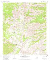
1967 Map of Fritz Canyon
USGS Topo · Published 1982About this map
Apache National Forest dominates this mid-1960s landscape, where the Blue River carves a deep valley through complex mountainous terrain. The map documents a rugged corner of Greenlee County defined by an extensive network of springs and stock tanks, such as Rattlesnake Spring and Yellowstone Tank, which supported the local ranching economy. Remote outposts like Fritz Ranch and Stacy Ranch are the primary human landmarks in a region largely navigated by a Pack Trail and various Jeep Trails. From the heights of Alder Peak down to the drainage of Cienega Creek, the map illustrates a topography of named canyons including Maple Canyon and Fritz Canyon. The presence of features like Holding Cienega Spring and Mud Springs highlights the critical importance of water sources in this high-elevation desert environment during the late twentieth century.
Find a feature on this map
47 named features on this map. Tap any name to fly to it.
Don’t see what you’re looking for? This feature index may not catch every label — zoom into the map to look around manually.
Map Details
Editions of this 1967 Fritz Canyon Map
3 editions found
Other maps of this area

1902 · Clifton
USGS Topo · 1:62,500

1913 · Morenci
USGS Topo · 1:125,000

1915 · Morenci
USGS Topo · 1:125,000

1954 · Clifton
USGS Topo · 1:250,000

1957 · Clifton
USGS Topo · 1:250,000

1958 · Clifton
USGS Topo · 1:250,000

1962 · Clifton
USGS Topo · 1:250,000

1962 · Clifton
USGS Topo · 1:62,500

1962 · Big Lue Mts
USGS Topo · 1:62,500
1967 · Alma Mesa
USGS Topo · 1:24,000