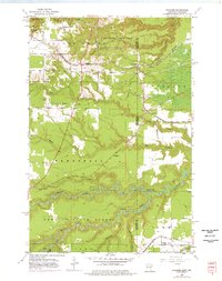
1954 Map of Frogner
USGS Topo · Published 1976About this map
Jay Cooke State Park and the Nemadji State Forest anchor this landscape along the state line between Minnesota and Wisconsin during the mid-1950s. The region is defined by a dense network of transit and timber extraction, with the Chicago Burlington and Quincy Railroad, Soo Line, and the Chicago Milwaukee St Paul and Pacific lines crisscrossing the terrain. An Old Railroad Grade and several Gravel Pits near Wrenshall point to the industrial activities that once moved through these woods. The winding course of the Nemadji River and its South Fork dominate the southern half of the map, carving through the townships of Wrenshall, Silver Brook, and Summit. Local life is marked by small settlements like Frogner and Foxboro, where a rural School and the Maccabee Cem serve as quiet landmarks for genealogists and local historians.
Find a feature on this map
28 named features on this map. Tap any name to fly to it.
Don’t see what you’re looking for? This feature index may not catch every label — zoom into the map to look around manually.
Map Details
Editions of this 1954 Frogner Map
4 editions found

Other maps of this area

1915 · Superior
USGS Topo · 1:48,000

1917 · Superior
USGS Topo · 1:62,500

1949 · Holyoke
USGS Topo · 1:48,000

1949 · Patzau
USGS Topo · 1:48,000

1953 · Duluth
USGS Topo · 1:250,000

1954 · West Duluth
USGS Topo · 1:24,000

1954 · Cloquet
USGS Topo · 1:24,000

1954 · Borea
USGS Topo · 1:24,000

1954 · Foxboro
USGS Topo · 1:24,000

1954 · Wrenshall
USGS Topo · 1:24,000