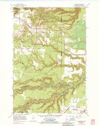
1954 Map of Frogner
USGS Topo · Published 1984About this map
The Minnesota Wisconsin borderlands in the mid-1950s are defined here by a heavy concentration of industrial transport and natural drainage systems. The Nemadji River and its tributary, the South Fork Nemadji River, carve winding paths through the lower half of the quadrangle, while the northern edge is dominated by the protected terrain of Jay Cooke State Park. Significant infrastructure surrounds the settlement of Wrenshall, where Gravel Pits sit adjacent to a complex rail network including the Chicago Milwaukee St Paul and Pacific and the Burlington Northern.
Find a feature on this map
24 named features on this map. Tap any name to fly to it.
Don’t see what you’re looking for? This feature index may not catch every label — zoom into the map to look around manually.
Map Details
Editions of this 1954 Frogner Map
4 editions found

Other maps of this area

1915 · Superior
USGS Topo · 1:48,000

1917 · Superior
USGS Topo · 1:62,500

1949 · Holyoke
USGS Topo · 1:48,000

1949 · Patzau
USGS Topo · 1:48,000

1953 · Duluth
USGS Topo · 1:250,000

1954 · West Duluth
USGS Topo · 1:24,000

1954 · Cloquet
USGS Topo · 1:24,000

1954 · Borea
USGS Topo · 1:24,000

1954 · Foxboro
USGS Topo · 1:24,000

1954 · Wrenshall
USGS Topo · 1:24,000