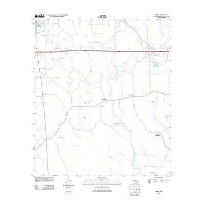
2012 Map of Frost
USGS Topo · Published 2012About this map
The Tickfaw River winds through this portion of Livingston Parish, defining a landscape of low-lying wetlands and bayous such as Edwards Bayou and Wall Bayou. The settlement of Livingston occupies the northwest corner, while the smaller communities of Springville and Wall Settlement are found further south and east. This era is characterized by a mix of rural residential development and family-linked landmarks, including the Springville Lookout Tower and several historic burial sites like Red Oak Cem and Zeigler Cem. The southern reach of the map reveals the water-based connectivity of the region at Smiley Landing and the Canoe Launch Rd, indicating the importance of the river system for local transit and recreation. Numerous small tributaries, such as Beaver Pond Br and Hog Br, feed into the larger waterways, creating a dense network of creeks that once shaped early land claims and homesteads.
Find a feature on this map
71 named features on this map. Tap any name to fly to it.
Don’t see what you’re looking for? This feature index may not catch every label — zoom into the map to look around manually.
Map Details
Editions of this 2012 Frost Map
This is the sole edition of this map. No revisions or reprints were ever made.
Other maps of this area

1934 · Denham Springs
USGS Topo · 1:62,500

1934 · Springfield
USGS Topo · 1:62,500

1939 · Springfield
USGS Topo · 1:62,500

1939 · Denham Springs
USGS Topo · 1:62,500

1942 · Satsuma
USGS Topo · 1:31,680

1949 · Albany
USGS Topo · 1:31,680

1950 · Doyle
USGS Topo · 1:31,680

1953 · Walker
USGS Topo · 1:24,000
1953 · French Settlement
USGS Topo · 1:24,000
1953 · Satsuma
USGS Topo · 1:24,000