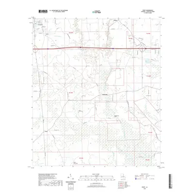
2020 Map of Frost
USGS Topo · Published 2020About this map
Livingston and the surrounding piney woods of Louisiana come into focus through a network of family-named roads and burial grounds. The landscape is defined by the winding course of the Tickfaw River, which creates a complex drainage system of branches and bayous including Hog Br, Beaver Pond Br, and Lizard Cr. This area retains a strong sense of local lineage, evidenced by the numerous small family cemeteries such as McLin Cem, Zeigler Cem, and Smiley-Davidson Cem that dot the countryside between Springville and Frost.
Find a feature on this map
79 named features on this map. Tap any name to fly to it.
Don’t see what you’re looking for? This feature index may not catch every label — zoom into the map to look around manually.
Map Details
Editions of this 2020 Frost Map
This is the sole edition of this map. No revisions or reprints were ever made.
Other maps of this area

1934 · Denham Springs
USGS Topo · 1:62,500

1934 · Springfield
USGS Topo · 1:62,500

1939 · Springfield
USGS Topo · 1:62,500

1939 · Denham Springs
USGS Topo · 1:62,500

1942 · Satsuma
USGS Topo · 1:31,680

1949 · Albany
USGS Topo · 1:31,680

1950 · Doyle
USGS Topo · 1:31,680

1953 · Walker
USGS Topo · 1:24,000
1953 · French Settlement
USGS Topo · 1:24,000
1953 · Satsuma
USGS Topo · 1:24,000