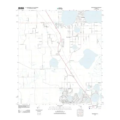
2012 Map of Frostproof
USGS Topo · Published 2012About this map
Frostproof serves as the central hub of this citrus-belt landscape, characterized by an intricate network of freshwater bodies and specialized aviation infrastructure. The town's grid is anchored between Lake Clinch and Reedy Lake, while the Frostproof Fire Tower stands to the west as a sentinel over the surrounding groves and flatlands. To the south, the terrain becomes increasingly aqueous, defined by the large expanse of Lake Livingston and the smaller, clustered Saddle Blanket Lakes. This era shows significant residential expansion in the southern reaches, where planned developments like Highland Lakes and Avon Park Lakes surround small interior basins such as Lake Olivia and Lake Lillian. The map also captures the distinct labor and industrial geography of the region at Maxcy Quarters and the outlying settlement of West Frostproof, providing a detailed look at the infrastructure that supports the local agricultural economy, from the Lake Clinch Airpark to the drainage systems of Old Town Cr.
Find a feature on this map
200 named features on this map. Tap any name to fly to it.
Don’t see what you’re looking for? This feature index may not catch every label — zoom into the map to look around manually.
Map Details
Editions of this 2012 Frostproof Map
This is the sole edition of this map. No revisions or reprints were ever made.
Other maps of this area

1952 · Lake Arbuckle SW
USGS Topo · 1:24,000

1952 · Babson Park
USGS Topo · 1:24,000

1952 · Lake Arbuckle
USGS Topo · 1:24,000

1952 · Lake Weohyakapka
USGS Topo · 1:24,000

1953 · Frostproof
USGS Topo · 1:24,000

1953 · Avon Park
USGS Topo · 1:24,000

1955 · Alturas
USGS Topo · 1:24,000

1956 · Bereah
USGS Topo · 1:24,000

1956 · Griffins Corner
USGS Topo · 1:24,000

1956 · Fort Pierce
USGS Topo · 1:250,000