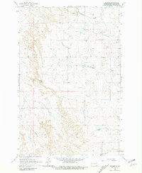
1962 Map of Fryburg
USGS Topo · Published 1981About this map
Fryburg serves as the focal point for this section of Billings County, situated along the tracks of the Burlington Northern railroad. The landscape is defined by the extraction economy of the early 1960s, notably the Fryburg Oil Field and numerous industrial markings for Scoria Pits and other mines scattered across the terrain. These features highlight the importance of mineral resources to the region's development during this era.
Find a feature on this map
11 named features on this map. Tap any name to fly to it.
Don’t see what you’re looking for? This feature index may not catch every label — zoom into the map to look around manually.
Map Details
Editions of this 1962 Fryburg Map
2 editions found
Other maps of this area

1953 · Dickinson
USGS Topo · 1:250,000

1957 · Dickinson
USGS Topo · 1:250,000

1961 · Daglum
USGS Topo · 1:62,500

1961 · Rocky Ridge
USGS Topo · 1:62,500

1962 · Tracy Mountain
USGS Topo · 1:24,000

1962 · Fryburg NE
USGS Topo · 1:24,000

1962 · Belfield SW
USGS Topo · 1:24,000

1962 · Fryburg
USGS Topo · 1:24,000

1962 · Fryburg NW
USGS Topo · 1:24,000

1962 · Belfield
USGS Topo · 1:24,000