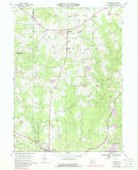
1967 Map of Fryburg
USGS Topo · Published 1988About this map
Oil and gas wells define the industrial footprint of this Clarion County landscape, dotting the terrain between Fryburg and Venus. The region is a patchwork of resource extraction and protected forests, with numerous strip mines operating alongside expansive reaches of State Game Lands No 63 and State Game Lands No 72. In the northern section, St Michaels Sch serves as a local landmark in Washington, while the southern corridor is shaped by the competing routes of the Penn Central and Baltimore and Ohio railroads. Small communities like Marble, Millerstown, and Huefner are linked by a complex drainage system including Little Paint Creek and East Sandy Creek. The map documents a mid-century period where the legacy of early petroleum drilling and active coal mining coexist with established rural settlements and churchyards like Dehner Cem.
Find a feature on this map
42 named features on this map. Tap any name to fly to it.
Don’t see what you’re looking for? This feature index may not catch every label — zoom into the map to look around manually.
Map Details
Editions of this 1967 Fryburg Map
4 editions found
Other maps of this area

1906 · Clarion
USGS Topo · 1:62,500

1907 · Clarion
USGS Topo · 1:62,500

1907 · Foxburg
USGS Topo · 1:62,500

1908 · Foxburg
USGS Topo · 1:62,500

1922 · Oil City
USGS Topo · 1:48,000

1922 · Tionesta
USGS Topo · 1:62,500

1924 · Oil City
USGS Topo · 1:62,500

1924 · Tionesta
USGS Topo · 1:62,500

1943 · Oil City
USGS Topo · 1:62,500

1946 · Tionesta
USGS Topo · 1:62,500