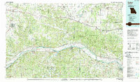
1985 Map of Fulton
USGS Topo · Published 1988About this map
The Missouri River corridor serves as the primary artery through this mid-Missouri landscape, flanked by a series of river islands including Dodds Island and Heckman Island. In the mid-1980s, the industrial footprint of the region was significantly marked by the Callaway Nuclear Powerplant in Auxvasse, standing in contrast to the nearby preservation of Graham Cave State Park. The map documents a critical transportation nexus where Interstate 70 and U S Highway 40 traverse the northern prairie lands, while the southern river bluffs are served by the Missouri-Kansas-Texas Railroad and the Missouri Pacific Railroad. Longstanding river towns like Hermann, Mokane, and Portland are shown at a time of transition, balancing their historic river-and-rail economy with modern agricultural and energy infrastructure. Deep creek systems, such as Loutre River and Gasconade River, continue to define the drainage patterns of the surrounding townships.
Find a feature on this map
128 named features on this map. Tap any name to fly to it.
Don’t see what you’re looking for? This feature index may not catch every label — zoom into the map to look around manually.
Map Details
Editions of this 1985 Fulton Map
2 editions found
Other maps of this area

1886 · Jefferson City
USGS Topo · 1:125,000

1888 · Tuscumbia
USGS Topo · 1:125,000

1890 · Louisiana
USGS Topo · 1:125,000

1890 · Mexico
USGS Topo · 1:125,000

1890 · Moberly
USGS Topo · 1:125,000

1890 · Hermann
USGS Topo · 1:125,000

1890 · Fulton
USGS Topo · 1:125,000

1894 · Tuscumbia
USGS Topo · 1:125,000

1894 · Jefferson City
USGS Topo · 1:125,000

1901 · De Soto
USGS Topo · 1:125,000