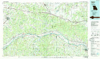
1985 Map of Fulton
USGS Topo · Published 1985About this map
Fulton and the mid-Missouri corridor are captured here during the mid-1980s, showcasing a landscape defined by the winding Missouri River and a dense network of transit routes. The map illustrates the convergence of river navigation and rail transport, with the Missouri - Kansas - Texas Railroad tracing the northern riverbank and the Missouri Pacific Railroad running to the south. This era shows the established path of Interstate 70 connecting towns like Williamsburg, Danville, and Warrenton.
Find a feature on this map
136 named features on this map. Tap any name to fly to it.
Don’t see what you’re looking for? This feature index may not catch every label — zoom into the map to look around manually.
Map Details
Editions of this 1985 Fulton Map
2 editions found
Other maps of this area

1886 · Jefferson City
USGS Topo · 1:125,000

1888 · Tuscumbia
USGS Topo · 1:125,000

1890 · Louisiana
USGS Topo · 1:125,000

1890 · Mexico
USGS Topo · 1:125,000

1890 · Moberly
USGS Topo · 1:125,000

1890 · Hermann
USGS Topo · 1:125,000

1890 · Fulton
USGS Topo · 1:125,000

1894 · Tuscumbia
USGS Topo · 1:125,000

1894 · Jefferson City
USGS Topo · 1:125,000

1901 · De Soto
USGS Topo · 1:125,000