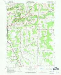
1960 Map of Gageville
USGS Topo · Published 1971About this map
The Ashtabula River carves a deep valley through this corner of Ashtabula County, where early 19th-century land patterns of the Connecticut Western Reserve remain visible in the road grid. Several small rural hubs serve the surrounding dairy and farmland, including Gageville, Sheffield Center, and Plymouth. Evidence of early transportation is preserved through multiple sites labeled Covered Bridge crossing the river, alongside the industrial presence of the Penn Central and N & W railroads. In the southern half of the quadrangle, Griggs Creek and Mill Creek drain toward the central valley, passing through hamlets like Bulah and Griggs Corners. The landscape is a mix of woodlots and open fields, with localized infrastructure like the Ashtabula Airport and the Radio Range Sta indicating the area's mid-century modernization.
Find a feature on this map
55 named features on this map. Tap any name to fly to it.
Don’t see what you’re looking for? This feature index may not catch every label — zoom into the map to look around manually.
Map Details
Editions of this 1960 Gageville Map
Other maps of this area

1905 · Andover
USGS Topo · 1:48,000

1905 · Ashtabula
USGS Topo · 1:62,500

1905 · Jefferson
USGS Topo · 1:62,500

1906 · Conneaut
USGS Topo · 1:62,500

1907 · Andover
USGS Topo · 1:62,500

1907 · Jefferson
USGS Topo · 1:62,500

1950 · Cleveland
USGS Topo · 1:250,000

1956 · Cleveland
USGS Topo · 1:250,000

1959 · Dorset
USGS Topo · 1:24,000
1959 · Leon
USGS Topo · 1:24,000
Featured Places
- Jefferson Township, OH
- Plymouth, OH
- Plymouth Township, OH
- Kingsville Township, OH
- Ashtabula Township, OH