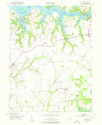
1953 Map of Galena
USGS Topo · Published 1955About this map
The Sassafras River dominates the northern landscape of this mid-century survey, defining the irregular border between Cecil and Kent counties. The shoreline is characterized by complex inlets like Woodland Creek and Turner Creek, interspersed with landings such as Shellcross Wharf. Inland, the economy of the Upper Eastern Shore is tied to the Pennsylvania railroad line, which connects agricultural hubs like Kennedyville and Lambson.
Find a feature on this map
45 named features on this map. Tap any name to fly to it.
Don’t see what you’re looking for? This feature index may not catch every label — zoom into the map to look around manually.
Map Details
Editions of this 1953 Galena Map
3 editions found
Other maps of this area

1898 · Tolchester
USGS Topo · 1:125,000

1899 · Dover
USGS Topo · 1:125,000

1900 · Cecilton
USGS Topo · 1:62,500

1900 · Betterton
USGS Topo · 1:62,500

1901 · Chestertown
USGS Topo · 1:62,500

1903 · Tolchester
USGS Topo · 1:125,000

1905 · Barclay
USGS Topo · 1:62,500

1906 · Dover
USGS Topo · 1:125,000

1908 · Tolchester
USGS Topo · 1:125,000

1920 · Dover
USGS Topo · 1:125,000