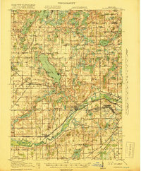
1918 Map of Galesburg
USGS Topo · Published 1918About this map
Galesburg and the surrounding river valley are shown here just as the United States entered the Great War, with the newly established Camp Custer dominating the eastern landscape. This military presence transformed the rural character of Charleston and Bedford townships, bringing intensive development alongside the existing Michigan Central and Grand Trunk Western rail corridors. The Kalamazoo River serves as the primary geographical axis, while the Michigan Railway (Electric) provides a look at the short-lived interurban era connecting settlements like Augusta and Richland.
Find a feature on this map
116 named features on this map. Tap any name to fly to it.
Don’t see what you’re looking for? This feature index may not catch every label — zoom into the map to look around manually.
Map Details
Editions of this 1918 Galesburg Map
5 editions found
Other maps of this area

1916 · Kalamazoo
USGS Topo · 1:62,500

1918 · Kalamazoo
USGS Topo · 1:62,500

1918 · Battle Creek
USGS Topo · 1:62,500

1918 · Union City
USGS Topo · 1:62,500

1918 · Galesburg
USGS Topo · 1:62,500

1918 · Leonidas
USGS Topo · 1:62,500

1922 · Schoolcraft
USGS Topo · 1:62,500

1943 · Battle Creek
USGS Topo · 1:62,500

1943 · Kalamazoo
USGS Topo · 1:62,500

1943 · Schoolcraft
USGS Topo · 1:62,500