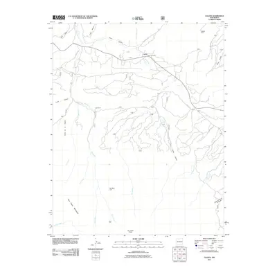
2011 Map of Gallina
USGS Topo · Published 2011About this map
Gallina and the neighboring community of Capulin center this northern New Mexico landscape, where high-altitude water sources and steep canyons dictate the layout of roads and ranches. The Capulin Post Office serves as a vital point of interest near the junction of French Mesa Rd, while the Austin Ranch occupies the more open valley floor to the south. This terrain is defined by dramatic elevation changes, rising from the Rio Gallina and Rio Capulin riverbeds toward the San Pedro Mountains and the heights of the San Pedro Peaks. Local land use is evidenced by a network of forest and county roads, including Fire Road 76 and Co Rd 414, which provide access to family-named landmarks like Mesa Gurule and water sources such as Chavez Spring. The geography transitions from the deep Cañon Capulin in the north to the distinctive Red Rock Cliff and Cañoncito de los Cordovas in the south.
Find a feature on this map
38 named features on this map. Tap any name to fly to it.
Don’t see what you’re looking for? This feature index may not catch every label — zoom into the map to look around manually.
Map Details
Editions of this 2011 Gallina Map
This is the sole edition of this map. No revisions or reprints were ever made.
Other maps of this area

1909 · Gallina
USGS Topo · 1:125,000

1940 · Cuba
USGS Topo · 1:62,500

1943 · Cuba
USGS Topo · 1:62,500

1953 · Arroyo Del Agua
USGS Topo · 1:24,000
1953 · Jarosa
USGS Topo · 1:24,000

1953 · Laguna Peak
USGS Topo · 1:24,000
1953 · Youngsville
USGS Topo · 1:62,500

1954 · Aztec
USGS Topo · 1:250,000

1955 · Llaves
USGS Topo · 1:62,500

1958 · Aztec
USGS Topo · 1:250,000