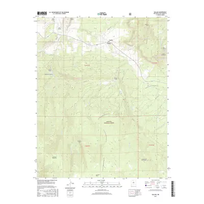
2017 Map of Gallina
USGS Topo · Published 2017About this map
Gallina sits at the intersection of mountain and mesa in Rio Arriba County, serving as a focal point for the surrounding high-elevation terrain. This modern survey illustrates a landscape defined by the drainage systems of Rio Gallina and Rio Capulin, where small settlements like Capulin and Cañoncito de los Cordovas are linked by rural routes like French Mesa Rd. The southwestern portion of the map is dominated by the high-altitude topography of the Santa Fe National Forest, containing the San Pedro Mountains and the prominent San Pedro Peaks. Local history and geography are preserved through family-named landmarks such as Cañada Gurule and Mesa Gurule. For those navigating the backcountry, the Continental Divide National Scenic Trail winds through the center of the map, passing significant geological markers like Red Rock Cliff and crossing numerous drainages including Jose Miguel Cr and Salitral Cr.
Find a feature on this map
44 named features on this map. Tap any name to fly to it.
Don’t see what you’re looking for? This feature index may not catch every label — zoom into the map to look around manually.
Map Details
Editions of this 2017 Gallina Map
This is the sole edition of this map. No revisions or reprints were ever made.
Other maps of this area

1909 · Gallina
USGS Topo · 1:125,000

1940 · Cuba
USGS Topo · 1:62,500

1943 · Cuba
USGS Topo · 1:62,500

1953 · Arroyo Del Agua
USGS Topo · 1:24,000
1953 · Jarosa
USGS Topo · 1:24,000

1953 · Laguna Peak
USGS Topo · 1:24,000
1953 · Youngsville
USGS Topo · 1:62,500

1954 · Aztec
USGS Topo · 1:250,000

1955 · Llaves
USGS Topo · 1:62,500

1958 · Aztec
USGS Topo · 1:250,000