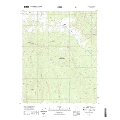
2020 Map of Gallina
USGS Topo · Published 2020About this map
Gallina and the small settlement of Capulin sit at the northern edge of this high-elevation terrain in Rio Arriba County. The landscape is defined by the drainage systems of Rio Gallina and Rio Capulin, which carve through a series of dramatic landforms including French Mesa and Mesa Alta Base. Within the Santa Fe National Forest, the Continental Divide National Scenic Trail winds through the central and southern sections, providing a clear route across the high country near Cecilia Canyon. To the south, the terrain rises toward the San Pedro Mountains and the San Pedro Peaks, where the Red Rock Cliff and Upper Gallina areas demonstrate the transition into more alpine environments. Smaller locations like Cahoncito de los Cordovas and various named canyons suggest the localized ranching or forest-use history of this corner of New Mexico.
Find a feature on this map
49 named features on this map. Tap any name to fly to it.
Don’t see what you’re looking for? This feature index may not catch every label — zoom into the map to look around manually.
Map Details
Editions of this 2020 Gallina Map
This is the sole edition of this map. No revisions or reprints were ever made.
Other maps of this area

1909 · Gallina
USGS Topo · 1:125,000

1940 · Cuba
USGS Topo · 1:62,500

1943 · Cuba
USGS Topo · 1:62,500

1953 · Arroyo Del Agua
USGS Topo · 1:24,000
1953 · Jarosa
USGS Topo · 1:24,000

1953 · Laguna Peak
USGS Topo · 1:24,000
1953 · Youngsville
USGS Topo · 1:62,500

1954 · Aztec
USGS Topo · 1:250,000

1955 · Llaves
USGS Topo · 1:62,500

1958 · Aztec
USGS Topo · 1:250,000