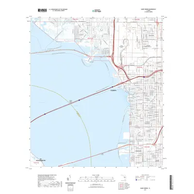
2021 Map of Gandy Bridge
USGS Topo · Published 2021About this map
Tampa and the eastern shores of Old Tampa Bay are defined here by a dense network of causeways and coastal developments. The map illustrates the massive footprint of Tampa International Airport and the surrounding neighborhoods of Drew Park and Rattlesnake. Three major crossings—the Howard Franklin Bridge, Gandy Bridge, and the W Courtney Campbell Cswy—connect the city to St. Petersburg and the western reaches of Hillsborough Co. Along the shoreline, recreational and conservation efforts are visible through the Rocky Creek Coastal Preserve Trl and various waterfront trails. The map also captures institutional landmarks like the Hillsborough Community College - Dale Mabry Campus and the American Legion Cem, providing a detailed look at the infrastructure of the Interbay Peninsula in the early 21st century.
Find a feature on this map
50 named features on this map. Tap any name to fly to it.
Don’t see what you’re looking for? This feature index may not catch every label — zoom into the map to look around manually.
Map Details
Editions of this 2021 Gandy Bridge Map
This is the sole edition of this map. No revisions or reprints were ever made.
Other maps of this area

1921 · Tampa
USGS Topo · 1:62,500

1921 · St Petersburg
USGS Topo · 1:62,500

1943 · St Petersburg
USGS Topo · 1:31,680

1943 · Gandy Bridge
USGS Topo · 1:31,680

1943 · Safety Harbor
USGS Topo · 1:31,680

1943 · Port Tampa
USGS Topo · 1:31,680

1943 · Oldsmar
USGS Topo · 1:24,000

1944 · Sulphur Springs
USGS Topo · 1:31,680

1944 · Tampa
USGS Topo · 1:31,680

1944 · Oldsmar
USGS Topo · 1:31,680