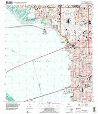
1998 Map of Gandy Bridge
USGS Topo · Published 2002About this map
The Interbay Peninsula and the urban sprawl of Tampa dominate this late-twentieth-century landscape, characterized by significant coastal infrastructure and mid-century educational institutions. The massive footprint of the Tampa International Airport serves as a central landmark, bordered by established neighborhoods like Drew Park. Two major spans, the Howard Frankland Bridge and the Gandy Bridge, cross Old Tampa Bay, illustrating the vital transportation links between Hillsborough and Pinellas counties.
Find a feature on this map
33 named features on this map. Tap any name to fly to it.
Don’t see what you’re looking for? This feature index may not catch every label — zoom into the map to look around manually.
Map Details
Editions of this 1998 Gandy Bridge Map
This is the sole edition of this map. No revisions or reprints were ever made.
Other maps of this area

1921 · Tampa
USGS Topo · 1:62,500

1921 · St Petersburg
USGS Topo · 1:62,500

1943 · St Petersburg
USGS Topo · 1:31,680

1943 · Gandy Bridge
USGS Topo · 1:31,680

1943 · Safety Harbor
USGS Topo · 1:31,680

1943 · Port Tampa
USGS Topo · 1:31,680

1943 · Oldsmar
USGS Topo · 1:24,000

1944 · Sulphur Springs
USGS Topo · 1:31,680

1944 · Tampa
USGS Topo · 1:31,680

1944 · Oldsmar
USGS Topo · 1:31,680