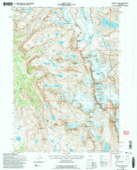
1991 Map of Gannett Peak
USGS Topo · Published 1997About this map
Gannett Peak crowns this portion of the Wind River Range, marking the highest elevation in the state along the boundary between Fremont and Sublette counties. This 1991 survey illustrates a landscape of active glaciation and high alpine topography, where the Bridger Wilderness meets the Fitzpatrick Wilderness. The intricate network of ice and water is defined by massive features like the Dinwoody Glacier and Gannett Glacier, which feed remote basins such as the Titcomb Lakes and Peak Lake. The map reveals the sophisticated trail systems used by mountaineers and backcountry travelers, including the High Line Trail and the Shannon Pass Trail. Notable summits such as Mount Woodrow Wilson, Mount Helen, and the jagged Bobs Towers create a formidable skyline of granite and perennial snow.
Find a feature on this map
78 named features on this map. Tap any name to fly to it.
Don’t see what you’re looking for? This feature index may not catch every label — zoom into the map to look around manually.
Map Details
Editions of this 1991 Gannett Peak Map
2 editions found
Other maps of this area

1909 · Fremont Peak
USGS Topo · 1:125,000

1955 · Thermopolis
USGS Topo · 1:250,000

1958 · Thermopolis
USGS Topo · 1:250,000

1962 · Thermopolis
USGS Topo · 1:250,000
1968 · Ink Wells
USGS Topo · 1:24,000

1968 · Fremont Peak North
USGS Topo · 1:24,000
1968 · Gannett Peak
USGS Topo · 1:24,000
1968 · Fremont Lake North
USGS Topo · 1:24,000
1968 · Downs Mountain
USGS Topo · 1:24,000
1968 · Bridger Lakes
USGS Topo · 1:24,000