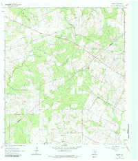
1963 Map of Garfield
USGS Topo · Published 1985About this map
The rural expanse of DeWitt County, Texas, is defined by its winding seasonal waterways and burgeoning energy landscape in the early 1960s. Ecleto Creek and Dry Ecleto Creek carve through the brushy terrain, which by this time was punctuated by numerous Gas Wells and an Oil Well, signaling the region's industrial shift. The small settlement of Garfield and the location of Old Davy serve as primary anchors for local history and genealogy, reflecting the dispersed nature of South Texas ranching communities. Fine red dashed lines throughout the survey delineate property fence lines, offering a rare look at land division patterns of the era. Cultural landmarks like the Salt Creek Cem and a prominent Radio Tower provide fixed points for researchers tracing the development of this section of the DeWitt and Karnes County border.
Find a feature on this map
17 named features on this map. Tap any name to fly to it.
Don’t see what you’re looking for? This feature index may not catch every label — zoom into the map to look around manually.
Map Details
Editions of this 1963 Garfield Map
3 editions found
Other maps of this area

1920 · Smiley
USGS Topo · 1:125,000

1953 · Beeville
USGS Topo · 1:250,000

1953 · Seguin
USGS Topo · 1:250,000

1956 · Beeville
USGS Topo · 1:250,000

1956 · Karnes City
USGS Topo · 1:62,500

1958 · Seguin
USGS Topo · 1:250,000

1960 · Beeville
USGS Topo · 1:250,000

1960 · Helena
USGS Topo · 1:24,000

1961 · Sample
USGS Topo · 1:24,000

1961 · New Davy
USGS Topo · 1:24,000