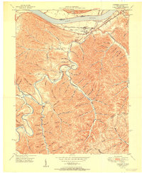
1951 Map of Garrison
USGS Topo · Published 1951About this map
Garrison and the small settlement of Bevins occupy a narrow terrace between the Ohio River and the steep, creek-cut hills of northern Lewis County. In this mid-century landscape, the Chesapeake and Ohio railroad corridor dictates the flow of commerce and movement along the riverbank, connecting river towns like Quincy to the broader industrial network. The interior terrain is defined by the winding course of Kinniconick Creek, where rural life is anchored by family-named landmarks and local institutions like Rock Hill Chapel and the Tannery School. Numerous family burial grounds, including the Skidmore Cemetery and Hubbard Cemetery, are tucked into hollows like Slate Hollow and Sherman Hollow. These sites, along with the Lookout Tower on Round Top, reflect a late-1940s topography where isolated homesteads and small schools were still the primary centers of community life before the consolidation of the modern era.
Find a feature on this map
116 named features on this map. Tap any name to fly to it.
Don’t see what you’re looking for? This feature index may not catch every label — zoom into the map to look around manually.
Map Details
Editions of this 1951 Garrison Map
This is the sole edition of this map. No revisions or reprints were ever made.
Other maps of this area

1915 · Garrison
USGS Topo · 1:62,500

1918 · Garrison
USGS Topo · 1:62,500

1919 · Vanceburg
USGS Topo · 1:62,500

1949 · Pond Run
USGS Topo · 1:24,000

1949 · Vanceburg
USGS Topo · 1:62,500

1949 · Garrison
USGS Topo · 1:24,000

1949 · Friendship
USGS Topo · 1:24,000

1949 · Buena Vista
USGS Topo · 1:24,000

1949 · Vanceburg
USGS Topo · 1:24,000

1949 · Brushart
USGS Topo · 1:24,000