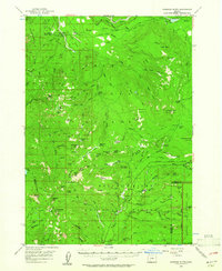
1956 Map of Garwood Butte
USGS Topo · Published 1961About this map
The Rogue River and Clearwater River headwaters converge in this mid-century survey of the Cascade Range, where the Umpqua National Forest and Rogue River National Forest meet the western edge of Crater Lake National Park. The landscape is defined by its early forest management and fire suppression infrastructure, including the Big Camas Ranger Sta and lookouts at Garwood Butte and Skookum Prairie Lookout.
Find a feature on this map
89 named features on this map. Tap any name to fly to it.
Don’t see what you’re looking for? This feature index may not catch every label — zoom into the map to look around manually.
Map Details
Editions of this 1956 Garwood Butte Map
3 editions found

Other maps of this area

1891 · Ashland
USGS Topo · 1:250,000

1893 · Ashland
USGS Topo · 1:250,000

1897 · Ashland
USGS Topo · 1:250,000

1917 · Diamond Lake
USGS Topo · 1:125,000

1944 · Abbott Butte
USGS Topo · 1:62,500

1947 · Abbott Butte
USGS Topo · 1:62,500

1955 · Quartz Mtn
USGS Topo · 1:62,500

1955 · Illahee Rock
USGS Topo · 1:62,500

1955 · Medford
USGS Topo · 1:250,000

1956 · Toketee Falls
USGS Topo · 1:62,500