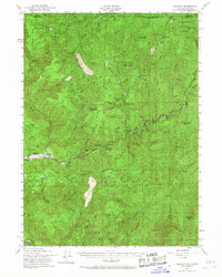
1951 Map of Gasquet
USGS Topo · Published 1968About this map
Gasquet and Darlingtonia sit as key points of settlement along the Redwood Highway in this mid-century survey of the California-Oregon borderlands. The landscape is defined by the complex drainage of the Smith River, particularly its North Fork and Middle Fork, which carve through the Siskiyou National Forest. Resource extraction is a primary theme of the era, evidenced by the presence of the Tyson Chrome Mine and Morrell Placer Mine, alongside smaller operations like the Cleopatra Mine and Browns Mine. These mining sites, often located in remote areas like Peridotite Canyon, illustrate the industrial footprint on the wild terrain.
Find a feature on this map
73 named features on this map. Tap any name to fly to it.
Don’t see what you’re looking for? This feature index may not catch every label — zoom into the map to look around manually.
Map Details
Editions of this 1951 Gasquet Map
5 editions found

Other maps of this area

1917 · Kerby
USGS Topo · 1:125,000

1918 · Kerby
USGS Topo · 1:125,000

1922 · Preston Peak
USGS Topo · 1:125,000

1929 · Crescent City
USGS Topo · 1:125,000

1945 · Ship Mountain
USGS Topo · 1:62,500

1945 · Kerby
USGS Topo · 1:125,000

1945 · Gasquet
USGS Topo · 1:62,500

1945 · Point St. George
USGS Topo · 1:62,500

1945 · Requa
USGS Topo · 1:62,500

1948 · Weed
USGS Topo · 1:250,000