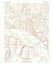
1979 Map of Geary South
USGS Topo · Published 1979About this map
The Canadian River meanders across this West-Central Oklahoma landscape, marking the tri-county intersection of Blaine, Canadian, and Caddo counties. The northern reaches are anchored by the town of Geary, where agricultural plateaus like Alfalfa Valley give way to the rugged drainage of Lumpmouth Creek. In the late 1970s, this area reflects a blend of traditional ranching and a growing energy sector, evidenced by numerous gas wells scattered across the hillsides. Transportation history is visible in the corridor of the Chicago Rock Island and Pacific railroad, while an Old Railroad Grade north of the river suggests earlier iterations of the regional rail network. The southern portion of the map centers on the transition near Hinton Junction, where the terrain drops into Fisher Canyon and West Walnut, providing a detailed look at the local topography before modern highway expansion further altered these rural communities.
Find a feature on this map
21 named features on this map. Tap any name to fly to it.
Don’t see what you’re looking for? This feature index may not catch every label — zoom into the map to look around manually.
Map Details
Editions of this 1979 Geary South Map
2 editions found
Other maps of this area

1893 · Fort Reno
USGS Topo · 1:62,500

1893 · Buggy Creek
USGS Topo · 1:62,500

1941 · Fort Reno
USGS Topo · 1:62,500

1942 · Fort Reno
USGS Topo · 1:62,500

1942 · Geary
USGS Topo · 1:62,500

1949 · Fort Reno
USGS Topo · 1:62,500

1951 · Binger
USGS Topo · 1:62,500

1955 · Clinton
USGS Topo · 1:250,000

1957 · Clinton
USGS Topo · 1:250,000

1967 · Fort Reno SW
USGS Topo · 1:24,000