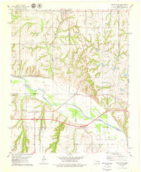
1979 Map of Geary South
USGS Topo · Published 1979About this map
The Canadian River flows across this Central Oklahoma landscape, serving as a natural boundary between Blaine, Canadian, and Caddo counties in the late 1970s. The town of Geary dominates the northern portion of the map, served by the Chicago Rock Island and Pacific railroad and its associated Geary Cem. Further south, the terrain becomes more varied with the presence of Fisher Canyon and View Canyon, alongside the fertile expanses of Alfalfa Valley.
Find a feature on this map
22 named features on this map. Tap any name to fly to it.
Don’t see what you’re looking for? This feature index may not catch every label — zoom into the map to look around manually.
Map Details
Editions of this 1979 Geary South Map
2 editions found
Other maps of this area

1893 · Fort Reno
USGS Topo · 1:62,500

1893 · Buggy Creek
USGS Topo · 1:62,500

1941 · Fort Reno
USGS Topo · 1:62,500

1942 · Fort Reno
USGS Topo · 1:62,500

1942 · Geary
USGS Topo · 1:62,500

1949 · Fort Reno
USGS Topo · 1:62,500

1951 · Binger
USGS Topo · 1:62,500

1955 · Clinton
USGS Topo · 1:250,000

1957 · Clinton
USGS Topo · 1:250,000

1967 · Fort Reno SW
USGS Topo · 1:24,000