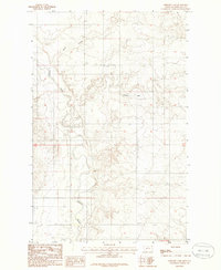
1983 Map of Geddart Lake
USGS Topo · Published 1985About this map
Poplar River winds through the heart of this landscape in Roosevelt County, Montana, carving a complex series of oxbows and meanders across the plains. This 1983 provisional survey captures the hydraulic character of the region, where the river's path is flanked by intricate contour work showing the eroded breaks and bluffs common to this part of the state. The entire area shown lies within the boundaries of the Fort Peck Indian Reservation, highlighting a territory defined by expansive open terrain and the vital water source of the river. To the north, the drainage of Kirns Coulee feeds toward the river valley, while the namesake Geddart Lake sits as a quiet landmark among the upland draws. The map serves as a technical record of the land's surface at the time of field checking in 1977, illustrating the sparse but distinct natural features of the Missouri River basin's northern tributaries.
Find a feature on this map
7 named features on this map. Tap any name to fly to it.
Don’t see what you’re looking for? This feature index may not catch every label — zoom into the map to look around manually.
Map Details
Editions of this 1983 Geddart Lake Map
2 editions found
Other maps of this area

1909 · Smoke Creek
USGS Topo · 1:62,500

1912 · Hay Creek
USGS Topo · 1:62,500

1912 · Poplar
USGS Topo · 1:62,500

1912 · Smoke Creek
USGS Topo · 1:62,500

1914 · Brockton
USGS Topo · 1:62,500

1954 · Wolf Point
USGS Topo · 1:250,000

1958 · Wolf Point
USGS Topo · 1:250,000

1972 · Poplar NE
USGS Topo · 1:24,000
1972 · Badger Creek
USGS Topo · 1:24,000
1972 · Brockton
USGS Topo · 1:24,000