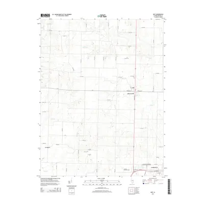
2015 Map of Geff
USGS Topo · Published 2015About this map
Geff and Jeffersonville occupy the heart of this Wayne County landscape, where the local road network centers on the intersection of Washington St and CR-7. The area is defined by a series of north-south flowing watercourses, including Martin Cr, Walton Cr, and Deer Cr, which carve through the terrain between small settlements and rural homesteads. To the south, the city of Fairfield expands with industrial and educational infrastructure, such as the Illinois Eastern Community Colleges-Frontier Community Coll and the Fairfield Municipal Airport. This 2015 survey provides significant detail for genealogists, as it identifies several family-named burial grounds like Cambell Cem, Bovee Cem, and Young Cem. The northern reach of the quadrangle is marked by In-Dan-Wayne Lake, while the western edge includes the small locality of Covington.
Find a feature on this map
58 named features on this map. Tap any name to fly to it.
Don’t see what you’re looking for? This feature index may not catch every label — zoom into the map to look around manually.
Map Details
Editions of this 2015 Geff Map
This is the sole edition of this map. No revisions or reprints were ever made.
Other maps of this area

1947 · Wayne City
USGS Topo · 1:62,500

1948 · Fairfield
USGS Topo · 1:62,500

1948 · Flora
USGS Topo · 1:62,500

1949 · Flora
USGS Topo · 1:62,500

1952 · Xenia
USGS Topo · 1:62,500

1958 · Belleville
USGS Topo · 1:250,000

1962 · Belleville
USGS Topo · 1:250,000
1968 · Johnsonville
USGS Topo · 1:24,000

1970 · Enterprise
USGS Topo · 1:24,000
1970 · Cisne
USGS Topo · 1:24,000