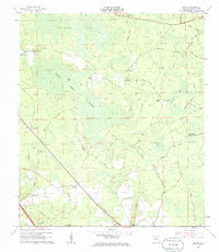
1962 Map of Genoa
USGS Topo · Published 1985About this map
The settlement at Genoa and the surrounding pine-turpentine landscape define this 1962 survey of Hamilton County. Several "stills" — including Camps Still, Blacks Still, and Purvis Still — are scattered across the terrain, indicating the historical naval stores industry that once dominated this region. The landscape is heavily marked by wetlands and named bays, such as Bee Haven Bay, Cheshire Bay, and Altmans Bay, while the Southern railroad line cuts through the southwest, providing a transportation corridor near Jerry Branch. Local social and family history is anchored by rural landmarks like Friendship Church, Spring Branch Church, and the Barton Cemetery. In the northern section, the Christie Lookout Tower stands near Christie Tower Road, overseeing the expansive Swift Creek Swamp and the intersection of local logging or access routes like Eightmile Still Road and Sugar Ridge Road.
Find a feature on this map
36 named features on this map. Tap any name to fly to it.
Don’t see what you’re looking for? This feature index may not catch every label — zoom into the map to look around manually.
Map Details
Editions of this 1962 Genoa Map
3 editions found

Other maps of this area

1954 · Valdosta
USGS Topo · 1:250,000

1955 · Jasper
USGS Topo · 1:24,000

1955 · Cypress Creek
USGS Topo · 1:24,000

1955 · Fargo SW
USGS Topo · 1:24,000

1958 · Valdosta
USGS Topo · 1:250,000

1959 · Valdosta
USGS Topo · 1:250,000

1961 · Live Oak East
USGS Topo · 1:24,000

1961 · Hillcoat
USGS Topo · 1:24,000

1961 · White Springs East
USGS Topo · 1:24,000

1961 · White Springs West
USGS Topo · 1:24,000