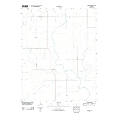
2009 Map of Gerlane
USGS Topo · Published 2009About this map
Gerlane sits at the center of this rural landscape, positioned just south of a bend in the Medicine Lodge River. The terrain is defined by a series of north-south and east-west country roads, such as College Hill Rd and Sunflower Rd, which trace the grid of Barber County's agricultural heartland. To the south, Liberty Cemetery remains a significant landmark for those researching family history in this corner of the state. Waterways like Wilson Slough and Brush Creek wind through the acreage, illustrating the natural drainage patterns that have influenced land use and settlement since the area was first organized. The network of naming, from Pleasant Hill Rd to Northstar Rd, reflects a classic Midwestern naming convention rooted in local geography and elevation.
Find a feature on this map
16 named features on this map. Tap any name to fly to it.
Don’t see what you’re looking for? This feature index may not catch every label — zoom into the map to look around manually.
Map Details
Editions of this 2009 Gerlane Map
This is the sole edition of this map. No revisions or reprints were ever made.
Other maps of this area

1889 · Anthony
USGS Topo · 1:125,000

1891 · Medicine Lodge
USGS Topo · 1:125,000

1891 · Anthony
USGS Topo · 1:125,000

1893 · Medicine Lodge
USGS Topo · 1:125,000

1955 · Pratt
USGS Topo · 1:250,000

1959 · Pratt
USGS Topo · 1:250,000

1972 · Sharon South
USGS Topo · 1:24,000
1972 · Kiowa
USGS Topo · 1:24,000

1973 · Hardtner NW
USGS Topo · 1:24,000
1973 · Gerlane
USGS Topo · 1:24,000