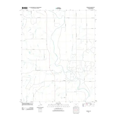
2012 Map of Gerlane
USGS Topo · Published 2012About this map
The small settlement of Gerlane serves as the focal point for this section of Barber County, where the meandering Medicine Lodge River shapes the geography of the high plains. The landscape is defined by a systematic grid of section roads and watercourses, including the notable Wilson Slough and several smaller tributaries like Antelope Cr and Brush Cr. This rural environment is a mosaic of drainage patterns and agricultural access routes, reflecting the region's long-standing reliance on its river systems. For those researching local heritage, the inclusion of Liberty Cem provides a significant touchstone for family history. The network of named routes, such as the Hardtner Shortcut and Gerlane Rd, illustrates the connectivity between these isolated homesteads and larger regional hubs during the early 21st century.
Find a feature on this map
24 named features on this map. Tap any name to fly to it.
Don’t see what you’re looking for? This feature index may not catch every label — zoom into the map to look around manually.
Map Details
Editions of this 2012 Gerlane Map
This is the sole edition of this map. No revisions or reprints were ever made.
Other maps of this area

1889 · Anthony
USGS Topo · 1:125,000

1891 · Medicine Lodge
USGS Topo · 1:125,000

1891 · Anthony
USGS Topo · 1:125,000

1893 · Medicine Lodge
USGS Topo · 1:125,000

1955 · Pratt
USGS Topo · 1:250,000

1959 · Pratt
USGS Topo · 1:250,000

1972 · Sharon South
USGS Topo · 1:24,000
1972 · Kiowa
USGS Topo · 1:24,000

1973 · Hardtner NW
USGS Topo · 1:24,000
1973 · Gerlane
USGS Topo · 1:24,000