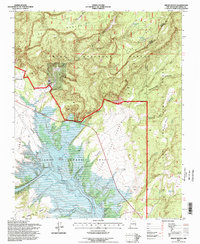
1995 Map of Ghost Ranch
USGS Topo · Published 1998About this map
The high desert landscape of Ghost Ranch is defined by a complex intersection of historic land grants and federal conservation. Spanning the northern reaches of the Abiquiu Reservoir, this terrain includes both the Lumbre Piedra Grant and the Joset Lobato Grant. Evidence of mid-century labor and infrastructure appears at the CCC Camp (Abandoned) located near the prominent drainage of Comanche Canyon.
Find a feature on this map
36 named features on this map. Tap any name to fly to it.
Don’t see what you’re looking for? This feature index may not catch every label — zoom into the map to look around manually.
Map Details
Editions of this 1995 Ghost Ranch Map
This is the sole edition of this map. No revisions or reprints were ever made.
Other maps of this area

1909 · Gallina
USGS Topo · 1:125,000

1918 · Abiquiu
USGS Topo · 1:125,000

1953 · Canones
USGS Topo · 1:24,000

1953 · Abiquiu
USGS Topo · 1:24,000

1953 · Alire
USGS Topo · 1:24,000

1953 · Echo Ampitheater
USGS Topo · 1:24,000

1953 · Magote Peak
USGS Topo · 1:24,000

1953 · Canjilon
USGS Topo · 1:24,000

1953 · Canjilon SE
USGS Topo · 1:24,000

1953 · Youngsville
USGS Topo · 1:24,000