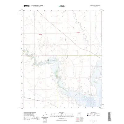
2023 Map of Gibbons Ranch
USGS Topo · Published 2023About this map
Pecos River waters define this arid landscape where the river flows into the northern reaches of Lake Sumner. The map highlights the transition between the rolling uplands of eastern New Mexico and the significant reservoir system that dominates the local geography. Scattered ranch roads like Smokey Draw Rd and Sneed Rd provide access to the expansive terrain surrounding the water, reflecting the area's ongoing reliance on cattle ranching and recreational land use. The boundary between Guadalupe and De Baca counties cuts through the center of the lake, underscoring the administrative divisions in this sparsely populated region. Settlement is concentrated near the water at Lake Sumner and the locality of Los Ojitos, where the confluence of Arroyo Potrillo and the river creates a focal point for the regional hydrologic network.
Find a feature on this map
20 named features on this map. Tap any name to fly to it.
Don’t see what you’re looking for? This feature index may not catch every label — zoom into the map to look around manually.
Map Details
Editions of this 2023 Gibbons Ranch Map
This is the sole edition of this map. No revisions or reprints were ever made.
Other maps of this area

1954 · Fort Sumner
USGS Topo · 1:250,000

1958 · Fort Sumner
USGS Topo · 1:250,000

1963 · Puerto De Luna
USGS Topo · 1:24,000

1964 · Canada Colorado
USGS Topo · 1:24,000

1964 · Fallon Ranch
USGS Topo · 1:24,000

1965 · Windmill Draw
USGS Topo · 1:24,000

1966 · Gibbons Ranch
USGS Topo · 1:24,000

1966 · Ojo Negro Creek
USGS Topo · 1:24,000

1966 · Alamogordo Dam
USGS Topo · 1:24,000

1966 · Cooper Ranch
USGS Topo · 1:24,000