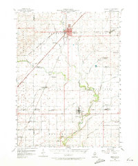
1957 Map of Gibson City
USGS Topo · Published 1973About this map
Gibson City anchors this mid-century survey of the Illinois prairie, serving as a vital rail crossroads where the Wabash, Illinois Central, and New York Chicago and St Louis railroads converge. The landscape is defined by the headwaters of the Sangamon River, which winds through the townships of Drummer, Dix, and Brown. This era captures a period of consolidation in rural education, evidenced by several decommissioned local landmarks such as Skeel Sch, Blackford Sch, and Sangamon Sch.
Find a feature on this map
68 named features on this map. Tap any name to fly to it.
Don’t see what you’re looking for? This feature index may not catch every label — zoom into the map to look around manually.
Map Details
Editions of this 1957 Gibson City Map
2 editions found

Other maps of this area

1906 · Urbana
USGS Topo · 1:62,500

1907 · Mahomet
USGS Topo · 1:62,500

1924 · Paxton
USGS Topo · 1:62,500

1927 · Paxton
USGS Topo · 1:62,500

1928 · Gibson City
USGS Topo · 1:62,500

1937 · Monticello
USGS Topo · 1:48,000

1943 · Monticello
USGS Topo · 1:62,500

1947 · Sibley
USGS Topo · 1:62,500

1948 · Buckley
USGS Topo · 1:62,500

1949 · Buckley
USGS Topo · 1:62,500