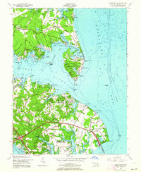
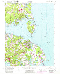
1954 Map of Gibson Island
USGS Topo · Published 1964About this map
Gibson Island sits at the mouth of the Magothy River, defined by its private drives, a prominent Golf Course, and the St Christopher by the Sea Church. This mid-century survey reveals a shoreline dense with maritime infrastructure, from the Ship to Shore Telephone Outlet to the iconic Baltimore Lighthouse standing in the Chesapeake Bay.
Find a feature on this map
94 named features on this map. Tap any name to fly to it.
Don’t see what you’re looking for? This feature index may not catch every label — zoom into the map to look around manually.
Map Details
Editions of this 1954 Gibson Island Map
5 editions found
Other maps of this area

1892 · Owensville
USGS Topo · 1:62,500

1892 · Annapolis
USGS Topo · 1:62,500

1893 · North Point
USGS Topo · 1:62,500

1894 · Relay
USGS Topo · 1:62,500

1895 · Owensville
USGS Topo · 1:62,500

1898 · Choptank
USGS Topo · 1:125,000

1898 · Tolchester
USGS Topo · 1:125,000

1899 · Patuxent
USGS Topo · 1:125,000

1903 · Tolchester
USGS Topo · 1:125,000

1904 · North Point
USGS Topo · 1:62,500