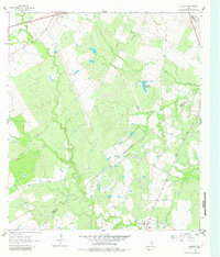
1961 Map of Gillett
USGS Topo · Published 1982About this map
Ecleto Creek and Elm Creek wind through this South Texas landscape, defining a rural territory at the intersection of Wilson, Gonzales, and Karnes counties. The community of Gillett sits in the southeast corner, while the small settlement of Pandora occupies the northwest, linked by the Southern Pacific railroad line. The map captures a moment in the early 1960s when the cattle-ranching culture, exemplified by the El Negro Ranch, coexisted with the growing energy infrastructure of the Manford Gas Field. Numerous petroleum-related features, including a Pipeline, Gas Wells, and Flowing Wells, are scattered across the terrain. Water management is central to the area's utility, marked by the Weinert Reservoir and various water tanks. Local travel is facilitated by a network of unimproved roads and specialized routes like the Shockley Trail, providing access to isolated cemeteries and the Roadside Park along the primary highway.
Find a feature on this map
23 named features on this map. Tap any name to fly to it.
Don’t see what you’re looking for? This feature index may not catch every label — zoom into the map to look around manually.
Map Details
Editions of this 1961 Gillett Map
Other maps of this area

1920 · Smiley
USGS Topo · 1:125,000

1942 · Dewville
USGS Topo · 1:62,500

1953 · Seguin
USGS Topo · 1:250,000

1956 · Dewville
USGS Topo · 1:62,500

1958 · Seguin
USGS Topo · 1:250,000

1960 · Kosciusko
USGS Topo · 1:24,000

1961 · Nixon
USGS Topo · 1:24,000
1961 · Stockdale
USGS Topo · 1:24,000
1961 · Alum
USGS Topo · 1:24,000

1961 · Gillett
USGS Topo · 1:24,000