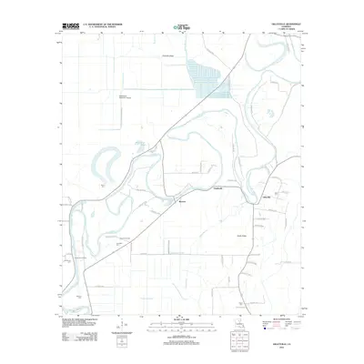
2012 Map of Gilleyville
USGS Topo · Published 2012About this map
The meandering Boeuf River defines the landscape of this Louisiana quadrangle, carving a winding path between the small settlements of Buckner, Charlieville, and Gilleyville. The river's influence is evident in the numerous oxbows and backwaters, such as The Basin and Cypress Bend, which sit alongside the elevated terrain of Palmetto Ridge and Snake Ridge. This area shows a blend of traditional riverfront habitation and industrial development, characterized by the Buckner Gas Field and the Woodland Plantation Airport. Local family history is preserved through numerous dispersed burial sites, including Landerneau Cem, Thomason Cem, and Adile Cem. Navigation and transport appear focused on rural landings and junctions like Landerneau Landing, where the river meets a network of parish roads. The presence of specialized drainage features such as Thomason Slough and Persimmon Slough reflects the ongoing management of this low-lying alluvial plain.
Find a feature on this map
66 named features on this map. Tap any name to fly to it.
Don’t see what you’re looking for? This feature index may not catch every label — zoom into the map to look around manually.
Map Details
Editions of this 2012 Gilleyville Map
This is the sole edition of this map. No revisions or reprints were ever made.
Other maps of this area

1935 · Alto
USGS Topo · 1:62,500

1939 · Fort Necessity
USGS Topo · 1:62,500

1940 · Monroe
USGS Topo · 1:62,500

1940 · Columbia
USGS Topo · 1:62,500

1955 · Jackson
USGS Topo · 1:250,000

1955 · Shreveport
USGS Topo · 1:250,000

1956 · Shreveport
USGS Topo · 1:250,000

1957 · Columbia
USGS Topo · 1:62,500

1957 · Mangham
USGS Topo · 1:62,500

1957 · Monroe South
USGS Topo · 1:24,000