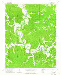
1963 Map of Gipsy
USGS Topo · Published 1964About this map
The Castor River meanders through the central hills of the Ozark Plateau in this early 1960s survey, marking the jagged boundary between Wayne and Bollinger counties. The small settlement of Gipsy sits south of a sharp river bend, while Buchanan serves as a northern anchor point for the local community. The landscape is defined by its deep hollows and timbered ridges, including Cowan Hollow, Hurricane Hollow, and Lime Kiln Hollow, which suggest the historic importance of logging and lime production in the region.
Find a feature on this map
32 named features on this map. Tap any name to fly to it.
Don’t see what you’re looking for? This feature index may not catch every label — zoom into the map to look around manually.
Map Details
Editions of this 1963 Gipsy Map
2 editions found
Other maps of this area

1930 · Coldwater
USGS Topo · 1:62,500

1933 · Marquand
USGS Topo · 1:62,500

1934 · Greenville
USGS Topo · 1:62,500

1935 · Zalma
USGS Topo · 1:62,500

1938 · Marquand
USGS Topo · 1:62,500

1939 · Greenville
USGS Topo · 1:62,500

1939 · Zalma
USGS Topo · 1:62,500

1949 · Rolla
USGS Topo · 1:250,000

1949 · Coldwater
USGS Topo · 1:62,500

1953 · Rolla
USGS Topo · 1:250,000