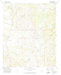
1972 Map of Gisela
USGS Topo · Published 1974About this map
Tonto Creek carves a deep path through this portion of the Tonto National Forest, shaping a landscape of high mesas and remote canyons in central Arizona. The settlement of Gisela serves as a small hub in this backcountry, situated near several historic cattle operations including the H Bar Ranch and the Seventy Six Ranch. This 1970s survey captures the area when cattle ranching and small-scale mining, such as the Pittsburg Tonto Mine, still dictated the local economy and land use. To the east, the rising slopes of the Sierra Ancha tower over the valley, while landmarks like Black Mountain and the Cocomunga Curry Basin define the northern horizons. The map reveals the vital importance of water in this arid environment, evidenced by numerous improved water sources like Bassett Tank, Mud Spring, and the Boone Moore Well scattered across the rugged terrain.
Find a feature on this map
71 named features on this map. Tap any name to fly to it.
Don’t see what you’re looking for? This feature index may not catch every label — zoom into the map to look around manually.
Map Details
Editions of this 1972 Gisela Map
3 editions found
Other maps of this area

1887 · Verde
USGS Topo · 1:250,000

1892 · Verde
USGS Topo · 1:250,000

1907 · Roosevelt
USGS Topo · 1:125,000

1909 · Four Peaks
USGS Topo · 1:125,000

1912 · Roosevelt
USGS Topo · 1:125,000

1936 · Payson
USGS Topo · 1:48,000

1937 · Diamond Butte
USGS Topo · 1:48,000

1942 · Payson
USGS Topo · 1:62,500

1943 · Diamond Butte
USGS Topo · 1:62,500

1954 · Holbrook
USGS Topo · 1:250,000