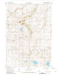
1963 Map of Gislason Lake
USGS Topo · Published 1982About this map
Gislason Lake lies at the center of this rural prairie landscape on the border of Lincoln and Lyon counties. The terrain is defined by the winding course of the South Branch Yellow Medicine River, which cuts a deep, meandering valley through the glacial till of Limestone and Nordland townships. The map reveals a post-war agricultural landscape where section-line roads connect isolated farmsteads and specialized features like the Zion Ch in the southeast corner. Significant water bodies, including Goose Lake and the marshy edges of Island Lake, dot the southern townships of Lake Stay and Island Lake, illustrating the natural drainage patterns before modern field tiling fully transformed the region's hydrology. Numerous Gravel Pit locations suggest the importance of local material extraction for the maintenance of the extensive township road network.
Find a feature on this map
12 named features on this map. Tap any name to fly to it.
Don’t see what you’re looking for? This feature index may not catch every label — zoom into the map to look around manually.
Map Details
Editions of this 1963 Gislason Lake Map
2 editions found
Other maps of this area

1953 · Watertown
USGS Topo · 1:250,000

1953 · New Ulm
USGS Topo · 1:250,000

1957 · New Ulm
USGS Topo · 1:250,000

1958 · New Ulm
USGS Topo · 1:250,000

1958 · Watertown
USGS Topo · 1:250,000

1963 · Dead Coon Lake
USGS Topo · 1:24,000

1963 · Gislason Lake
USGS Topo · 1:24,000

1963 · Russell
USGS Topo · 1:24,000

1963 · Tyler
USGS Topo · 1:24,000

1963 · Lynd
USGS Topo · 1:24,000