1985 Map of Glendale
USGS Topo · Published 1985About this map
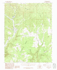
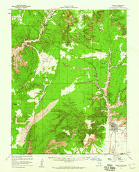
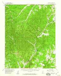
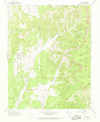
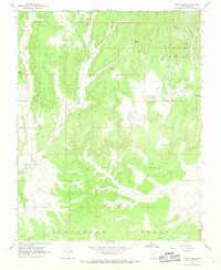
Glendale occupies the central corridor of Long Valley in this mid-1980s survey, where the town site is bounded by the Virgin River and the rising slopes of the Glendale Bench. This provisional mapping effort, based on aerial photography from the late 1970s, details a landscape defined by sharp vertical relief. To the south and east, the dramatic formations of the Kanab Cliffs, Elkheart Cliffs, and the White Terrace create a natural barrier, while narrow drainages like Lydias Canyon and Madison Canyon cut through the high ground. Local history interests are noted at the town's edge, including the Cem and a nearby Gravel Pit. The map captures the hydrological network of the East Fork Virgin River as it meets various hollows such as Bens Hollow and Grassy Hollow, illustrating how water shaped the settlement patterns and grazing lands of Southern Utah.
Find a feature on this map
31 named features on this map. Tap any name to fly to it.
Don’t see what you’re looking for? This feature index may not catch every label — zoom into the map to look around manually.
Map Details
Editions of this 1985 Glendale Map
This is the sole edition of this map. No revisions or reprints were ever made.
Other maps of this area

1886 · Kanab
USGS Topo · 1:250,000

1953 · Cedar City
USGS Topo · 1:250,000

1954 · Johnson
USGS Topo · 1:62,500
1957 · Kanab
USGS Topo · 1:62,500

1958 · Cedar City
USGS Topo · 1:250,000
1958 · Orderville
USGS Topo · 1:62,500

1962 · Cedar City
USGS Topo · 1:250,000
1966 · Alton
USGS Topo · 1:24,000
1966 · Bald Knoll
USGS Topo · 1:24,000
1980 · Kanab
USGS Topo · 1:100,000