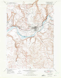
1947 Map of Glenns Ferry
USGS Topo · Published 1975About this map
The Snake River dominates this mid-century landscape, carving through the high desert of Elmore County where the historic southern route of the Oregon Trail followed its banks. This survey captures Glenns Ferry as a vital river crossing and railroad hub, with the Union Pacific line running parallel to the water. The complex network of the Main Siphon Canal, Ditch segments, and Flumes illustrates the intensive irrigation infrastructure required to sustain agriculture in this arid region. Notably, the map marks Three Island Crossing, a famous ford for westward pioneers, and includes an Historic Marker and a nearby Cem. The rugged southern terrain is defined by the steep descents of Deadman Canyon leading toward Deadman Flat, where the Deadman Falls Dam sits at a sharp bend in the drainage, while the northern uplands are punctuated by the prominent King Hill.
Find a feature on this map
23 named features on this map. Tap any name to fly to it.
Don’t see what you’re looking for? This feature index may not catch every label — zoom into the map to look around manually.
Map Details
Editions of this 1947 Glenns Ferry Map
2 editions found
Other maps of this area

1892 · Camas Prairie
USGS Topo · 1:125,000

1893 · Camas Prairie
USGS Topo · 1:125,000

1947 · Hammett
USGS Topo · 1:24,000

1947 · Glenns Ferry
USGS Topo · 1:24,000

1947 · Pasadena Valley
USGS Topo · 1:24,000

1948 · Pasadena Valley
USGS Topo · 1:24,000

1948 · Hammett
USGS Topo · 1:24,000

1948 · Glenns Ferry
USGS Topo · 1:24,000

1948 · Twentymile Butte
USGS Topo · 1:24,000

1948 · Glenns Ferry
USGS Topo · 1:62,500