
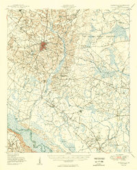
1950 Map of Glennville
USGS Topo · Published 1950About this map
Glennville serves as the central hub of this 1950 survey, anchored by its distinctive red-tinted street grid and proximity to several localized milling operations. The landscape is characterized by a dense network of watercourses and millponds, including Brewton Millpond, Edwards Millpond, and Dickey Powell Millpond, which suggest a heritage of local industry along the Beards Creek drainage. To the east, the Camp Stewart Military Reservation occupies a significant portion of the terrain, while the southern boundary is defined by the winding course of the Altamaha River and its associated lowlands like Back Swamp and Vincent Swamp. Genealogists will find a wealth of community landmarks, from rural schools like Rye Patch Sch and Ochs Grove School to numerous country churches and family-named cemeteries such as Gays of the Bays Cem.
Find a feature on this map
60 named features on this map. Tap any name to fly to it.
Don’t see what you’re looking for? This feature index may not catch every label — zoom into the map to look around manually.
Map Details
Editions of this 1950 Glennville Map
2 editions found
Other maps of this area

1918 · Jesup
USGS Topo · 1:62,500

1918 · Hinesville
USGS Topo · 1:62,500

1919 · Claxton
USGS Topo · 1:62,500

1920 · Pembroke
USGS Topo · 1:62,500

1920 · Glennville
USGS Topo · 1:62,500

1943 · Ludowici
USGS Topo · 1:62,500

1943 · Jesup
USGS Topo · 1:62,500

1944 · Claxton
USGS Topo · 1:62,500

1944 · Glennville
USGS Topo · 1:62,500

1944 · Hinesville
USGS Topo · 1:62,500