
1960 Map of Glenwood
USGS Topo · Published 1962About this map
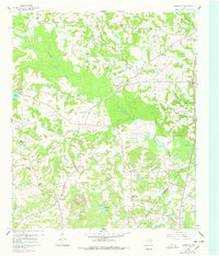
Glenwood and Diana anchor this east Texas landscape in the early 1960s, a period marked by the maturing infrastructure of the East Texas Oil Field. The southern portion of the map reveals the density of energy production through numerous unnamed pumping stations and a Sludge Pit, while the Upshur Co Gregg Co line bisects the industrial activity. Rural life is well-documented through a network of small churches and schools, including Valley View Sch and New Bethlehem Sch, which served the scattered residents living along the wooded reaches of Little Cypress Creek. Genealogists will find significant value in the various family and community burial grounds such as Mattox Cem, Floyds Cem, and George Cem. The physical remnants of earlier transport are visible in the form of an Old Railroad Grade winding through the eastern hills, providing a trace of the area's timber or transit history prior to the modern highway era.
Find a feature on this map
35 named features on this map. Tap any name to fly to it.
Don’t see what you’re looking for? This feature index may not catch every label — zoom into the map to look around manually.
Map Details
Editions of this 1960 Glenwood Map
2 editions found
Other maps of this area

1956 · Tyler
USGS Topo · 1:250,000

1960 · Bettie
USGS Topo · 1:24,000

1960 · White Oak
USGS Topo · 1:24,000

1960 · Gilmer
USGS Topo · 1:24,000

1960 · Coffeeville
USGS Topo · 1:24,000

1960 · Gladewater
USGS Topo · 1:24,000

1962 · Ashland
USGS Topo · 1:24,000

1962 · Longview Heights
USGS Topo · 1:24,000

1962 · Ore City
USGS Topo · 1:24,000

1984 · Tyler
USGS Topo · 1:250,000