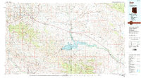
1986 Map of Globe
USGS Topo · Published 1986About this map
Industrial mining operations and tribal lands define this mid-1980s landscape, where the copper-rich districts of Miami and Globe meet the western edge of the San Carlos Indian Reservation. Huge open-pit workings at the Inspiration and Miami Mine stand in contrast to the surrounding Tonto National Forest. To the south and east, the Gila River winds through the Gila Valley, feeding the significant San Carlos Reservoir.
Find a feature on this map
77 named features on this map. Tap any name to fly to it.
Don’t see what you’re looking for? This feature index may not catch every label — zoom into the map to look around manually.
Map Details
Editions of this 1986 Globe Map
2 editions found
Other maps of this area

1900 · Florence
USGS Topo · 1:125,000

1901 · Globe
USGS Topo · 1:62,500

1902 · Globe
USGS Topo · 1:62,500

1902 · Florence
USGS Topo · 1:125,000

1907 · Roosevelt
USGS Topo · 1:125,000

1909 · Four Peaks
USGS Topo · 1:125,000

1910 · Ray
USGS Topo · 1:62,500

1911 · Winkelman
USGS Topo · 1:125,000

1912 · Roosevelt
USGS Topo · 1:125,000

1913 · Winkelman
USGS Topo · 1:125,000